............Article on forest.................कटते वन, घटता धरती का आवरण प्रमोद भार्गव राष्ट्र की अद्वितीय और अटूट प्राकृतिक संपदा तथा आदिम जातियों की आजीविका के प्रमुख साधन रहे जंगल समूचे भारत में तेजी से लुप्त हो रहे हैं। देश का वन विभाग अब तक यह दावा करता रहा था कि भारत के कुल भू-भाग में 19 प्रतिशत जंगल हैं, लेकिन हाल ही में भारतीय वन सर्वेक्षण ने खुलासा किया है कि बीते 10 साल के भीतर 3000 वर्ग किमी जंगलों का सफाया हो चुका है। अगर यही रफ्तार रही तो सौ सालों में दो तिहाई घने जंगल नष्ट हो जाएंगे। इसके पहले संयुक्त राष्ट्र संघ ने उपग्रह के माध्यम से दुनिया भर के जंगलों के छायाचित्र लेकर एक रिपोर्ट तैयार की थी, जिसमें सरकारी दावों को पूरी तरह झुठलाते हुए दावा किया गया था कि देश में केवल आठ प्रतिशत भू-भाग वनाच्छादित रह गया है। इस रिपोर्ट के मुताबिक, लगभग 3290 लाख हेक्टेयर में फैले भू-क्षेत्र में 1989 तक 19.5 भू-भाग में जंगल थे, जिनकी कटाई 15 लाख हेक्टेयर प्रति वर्ष की दर से जारी रही। नतीजतन ये वन घटकर केवल आठ फीसदी बताए गए थे। वनों का आकलन दस साल पहले की रिपोर्ट में दर्शाए गए आंकड़ों के तुलनात्मक अध्ययन से होता है। दस साल पहले देश में कुल 7.83 करोड़ हेक्टेयर क्षेत्र में वन थे, जो अब घटकर 24 फीसदी शेष बचे हैं। इनका विनाश विकास के बहाने औद्योगीकरण की भेंट चढ़ गया। इस रिपोर्ट के अनुसार बीते दो साल के भीतर ही 367 वर्ग किमी वन्य क्षेत्र नष्ट हो गया। इसके चलते देश के कुल क्षेत्रफल में जंगल और पेड़ों की मौजूदगी घटकर 23.81 फीसदी रह गई है, जो 33 फीसदी होनी चाहिए थी। इस स्थिति ने जंगल से जुड़े 20 करोड़ लोगों की आजीविका पर संकट के बादल गहरा दिए हैं। आधुनिक और औद्योगिक विकास के चलते पहले भी करीब 4 करोड़ वनवासियों को विस्थापित करके उन्हें भगवान भरोसे छोड़ दिया गया है। ऐसा नहीं है कि वन केवल हमारे देश में ही नष्ट हो रहे हैं? दुनिया भर में तेजी बढ़ रही आबादी के दबाव और मनुष्य द्वारा वन संपदा से ज्यादा से ज्यादा धन कमाने की लालसा के कारण पूरी दुनिया में जंगलों का दायरा सिकुड़ता जा रहा है। पिछले दस सालों के भीतर वन विनाश में तेजी आई है। ब्राजील में 17 हजार, म्यांमार में 8 हजार, इंडोनेशिया में 12 हजार, मेक्सिको में 7 हजार, कोलंबिया में 6 हजार पांच सौ, थाईलैंड में 6 हजार और भारत में भी 4 हजार प्रति वर्ग किमी के हिसाब से वनों का विनाश हो रहा है। वनों के इस महाविनाश का सबसे ज्यादा खामियाजा हमारे देश को उठाना होगा, क्योंकि जैव विविधता की दृष्टि से सबसे ज्यादा भारत संपन्न देश है। ऐसा इसलिए है, क्योंकि भारत की जलवायु में विविधता है और भौगोलिक बनावट में भी भिन्नता है। करीब 3290 लाख हेक्टेयर क्षेत्र में फैले हमारे देश में एक लाख हेक्टेयर क्षेत्र में शीतल और तरल जलवायु वाला हिमालय का भूखंड है। दूसरी तरफ राजस्थान और गुजरात के रेगिस्तान हैं। जहां केवल 20 सेंटीमीटर एक साल में औसत वर्षा होती है। इसके ठीक विपरीत असम के कुछ ऐसे भू-भाग हैं, जहां वर्षा का वार्षिक औसत 1100 सेमी है। लगभग 7500 किमी लंबे हमारे समुद्र तट हैं, जहां समुद्री जीव और वनस्पतियों का अनूठा भंडार है। जंगलों के विनाश के कारण भू-क्षरण में भी तेजी आई है। दुनिया में 2600 करोड़ टन मिट्टी की पृथ्वी पर ऊपरी परत है, जो बरसात में जल धाराओं से कटाव आ जाने के कारण निरंतर समुद्र में समाती जा रही है। देश में भू-क्षरण की रफ्तार 1200 करोड़ टन है। लिहाजा, प्रति मिनट पांच हेक्टेयर भूमि का क्षरण हो रहा है। प्रत्येक बरसात में एक हेक्टेयर भूमि में से 16.35 टन मिट्टी बह जाती है। यदि इस दिशा में सुधार नहीं किया गया तो अगले 20 सालों में एक तिहाई कृषि भूमि नष्ट हो जाने की आशंका है। वर्तमान में अकेले भू-क्षरण के कारण प्रति वर्ष 2800 करोड़ रुपये का नुकसान हो रहा है। पूरी दुनिया में जीवों और वनस्पतियों की एक करोड़ प्रजातियां पाई जाती हैं। इनमें अभी तक 14 लाख जीवों और वनस्पतियों की पहचान कर उन्हें सूचीबद्ध किया गया है। इनमें से 50 से लेकर 90 प्रतिशत प्रजातियां भारत के जंगलों में पाई जाती हैं। इससे सहज ही अनुमान लगाया जा सकता है कि भारत के जंगल कितने उपयोगी हैं, लेकिन अफसोस कि बड़े पैमाने पर जंगलों की कटाई हो रही है। वन माफिया तो वनों के पीछे हाथ धोकर पड़ गया है। अगर वनों के विनाश को सख्ती से काबू नहीं किया जाता तो हालात विकराल होना तय है।
Tuesday, June 5, 2012
पर्यावरण चौपट कर रहा इस्पात व लौह उद्योग
नई दिल्ली भारत की स्टील और लौह अयस्क कंपनियों की पहली बार की गई पर्यावरण रेटिंग में इस्पात इंडस्ट्रीज को पहले स्थान पर जगह मिली है। प्रतिष्ठित गैर-सरकारी संगठन विज्ञान और पर्यावरण केंद्र (सीएसई) की ओर से किए गए इस आकलन में एस्सार स्टील और राष्ट्रीय इस्पात निगम को दूसरे और तीसरे स्थान पर जगह मिली है। वैसे, इस रेटिंग को जारी करते हुए वन एवं पर्यावरण मंत्री जयंती नटराजन ने माना कि पर्यावरण मानकों को लागू करने के लिहाज से इस उद्योग की स्थिति बेहद बुरी है। जयंती के मुताबिक, उन्हें यह देखकर बेहद हैरानी हो रही है कि अपने देश का इस्पात और लौह अयस्क (आयरन ओर) उद्योग पर्यावरण के मानकों पर इतना पीछे है। सरकार इस स्थिति को ठीक करने के लिए न सिर्फ नियमों को और मजबूत करेगी, बल्कि इनकी निगरानी व्यवस्था को भी दुरुस्त करेगी। इस रेटिंग के दौरान यह भी पता चला है कि ये कंपनियां आसानी से पर्यावरण अनुकूल उपाय अपना सकती हैं। इसके लिए जरूरी तकनीक बेहद आसानी से उपलब्ध है। यहां तक कि ऐसी तकनीक इनके लिए आर्थिक रूप से भी फायदेमंद है। इसके बावजूद अधिकांश कंपनियां साहस नहीं दिखा रही हैं। सीएसई की महानिदेशक सुनीता नारायण ने कहा कि देश की शीर्ष 21 स्टील निर्माता कंपनियों का 150 तरह के पर्यावरण संबंधी मानदंडों पर मूल्यांकन किया गया। लेकिन इस उद्योग को कुल मिलाकर 19 फीसद अंक ही मिले, जबकि यह उद्योग देश की भूमि, जल और कच्चा माल जैसे संसाधनों को बहुत बड़े पैमाने पर इस्तेमाल करता है। भारत में ये कंपनियां जितनी बिजली का इस्तेमाल करती हैं, वह अंतरराष्ट्रीय मानकों से 50 फीसद ज्यादा है। इसी तरह पानी की खपत भी ये तीन गुना ज्यादा करती हैं। नारायण ने पारदर्शिता नहीं दिखाने के लिए सार्वजनिक क्षेत्र की कंपनी सेल की जोरदार आलोचना भी की।
2023 तक होगी मंगल पर मानव बस्ती!
वेलिंगटन, एजेंसी : यूरोपीय देश नीदरलैंड्स ने आने वाले सिर्फ अगले ग्यारह सालों में अपने चार अंतरिक्ष यात्रियों को मंगल ग्रह पर बसने के लिए भेजनी की तैयारी कर ली है। मार्स-वन नामका ये अंतरिक्षयान वर्ष 2023 में केवल पृथ्वी से मंगल ग्रह का सफर करेगा। यानी यह कभी धरती पर वापस लौटेगा नहीं। यह एक निजी कंपनी का अंतरिक्ष अभियान है। इस अभियान को मूर्तरूप देने वालों में हैं डच उद्योगपति और अनुसंधानकर्ता बास लैंड्सडार्प। लैंड्सडार्प इससे पहले एक वैकल्प ऊर्जा संबंधी कंपनी भी चलाते रहे हैं। हालांकि यह अभियान अन्य निजी कंपनियों की तरह अभी उतने परिष्कृत रूप में सामने नहीं आया है जिस तरह अरबपति मस्क, पॉल एलन या जेफ बेजोस ने अपने स्पेस ट्रैवल संबंधी अभियान की शुरुआत की थी। मंगल ग्रह पर पहली मानव बस्ती बसाने के लिए पहले चरण के तहत वर्ष 2016 में सबसे पहला अभियान भेजा जाएगा। इसमें केवल संचार संबंधी उपग्रह भेजे जाएंगे। वर्ष 2018 में दूसरा अंतरिक्ष रोवर यान भेजा जाएगा। यह केवल लाल ग्रह के रूखे-सूखे माहौल में कुछ चुनिंदा सबसे अच्छे स्पॉट ढूंढेगा जहां मानव बस्ती बसाई जा सके। फिर तीसरे चरण में वर्ष 2020 में मंगल पर सोलर पैनल समेत मानव बस्ती बनाने संबंधी सामान लाल ग्रह पर भेजा जाएगा। इसमें वह मशीनें भी शामिल हैं जो लाल ग्रह को इंसानों के योग्य बनाने के लिए वहां मंगल ग्रह के मूल तत्वों को ऑक्सीजन और जल में परिवर्तित करेगी। इसके बाद ही 14 सितंबर 2022 को मंगल ग्रह पर चार अंतरिक्ष यात्रियों को हमेशा के लिए वहां बसने को भेजा जाएगा। उन्हें वहां नई बस्ती बनाने में दस महीने लगेंगे। हालांकि इसका प्रशिक्षण उन्हें दशकों से दिया जा रहा है। इन अंतरिक्ष यात्रियों का सबसे कड़ा परीक्षण यही होगा कि जब आप वहां बिना नहाए महीनों तक कठिन परिस्थितियों में रह रहे हों और अपना संतुलन बनाए रखते हुए किसी की हत्या न कर बैठें। लैंड्सडार्प की योजना है कि वह कठिन चुनौतियों के लिए तैयार ऐसे कुछ अंतरिक्ष यात्रियों को हर दो साल पर मंगल ग्रह पर बनने वाली मानव बस्तियों में भेजेंगे। लेकिन वहां जाने वाले को कभी भी धरती पर वापस नहीं बुलाया जाएगा। ये पूरी तरह से एक नई दुनिया होगी। इस मिशन का पूरा खर्च मीडिया स्पेटकल नामक कंपनी उठाएगी।
आर्कटिक में गर्मी से टुंड्रा की झाडि़यां बनीं पेड़
उत्तरी ध्रुव में स्थित आर्कटिक क्षेत्र में टुंड्रा सर्वाधिक ठंडा क्षेत्र होने के कारण वहां कभी पेड़ नहीं पाए जाते। लेकिन आर्कटिक क्षेत्र में लगातार बढ़ती गर्मी के कारण वहां की वनस्पतियों में भी जमीन-आसमान का फर्क आ गया है। वहां पर हमेशा से ही बमुश्किल छोटी झाडि़यां पनपती थीं। लेकिन पिछले कुछ दशकों से इन झाडि़यों का कद इतना बढ़ गया है कि वह पेड़ के आकार की हो गई हैं। वैज्ञानिकों का कहना है कि नए शोध में पाया गया है कि टुंड्रा के फिनलैंड और पश्चिमी साइबेरिया के बीच करीब दस से पंद्रह फीसदी भूमि पर पेड़ के आकार की नई झाडि़यां उग आई हैं। इनका कद 6.6 फीट से भी ऊंचा है। ऑक्सफोर्ड यूनिवर्सिटी के बायोडायवर्सिटी इंस्टीट्यूट के अनुसंधानकर्ता मार्क मेकस फ्यूरिया ने बताया कि सिर्फ तीस साल पहले तक टुंड्रा क्षेत्र में किसी ने पेड़ कभी देखे तक नहीं थे। उनका कहना है कि आर्कटिक क्षेत्र में ही कभी 3.3 फीट से ऊंची झाडि़यां कभी नहीं हुईं जोकि करीब एक रेनडीयर (एक प्रकार का हिरण) के कद की होती हैं। लेकिन वैज्ञानिकों ने पर्यावरण में इस बड़े बदलाव पर तब ध्यान केंद्रित किया जब स्थानीय लोगों ने कहा कि अब उन्हें रेनडीयर दिखना बंद हो गए हैं। पर्यावरण में बदलाव के कारणों को समझने के लिए उत्तरी पश्चिमी यूरेशियाई टुंड्रा इलाके में वैज्ञानिकों के दल ने स्थानीय लोगों और चरवाहों और वेधशालाओं की मदद से इन इलाकों के तापमान के आंकड़े, जंगलों में झाडि़यों के बढ़ने के उपग्रहों से एकत्र आंकड़े जुटाए। इसके अलावा उन्होंने यह भी मालूम किया कि इन इलाकों में हरियाली का इलाका पहले कितना अधिक बढ़ा है। नेचर पत्रिका में प्रकाशित इस शोध में बताया गया है कि ज्यादातर नई झाडि़यां हर वर्ष जुलाई के महीने में उगी हैं। अनुसंधानकर्ता मैसिया फुरिया का कहना है कि पहले यहां नन्हीं झाडि़यों या घास से अधिक कुछ इसलिए नहीं उग पाता था क्योंकि ऊंचे कद के साथ वनस्पति का पर्यावरण की दुरुह स्थितियों का सामना कर पाना संभव नहीं था। लेकिन अब तापमान पहले की अपेक्षा बहुत घट गया है। टुंड्रा के इस इलाके में पर्यावरण परिवर्तन की यह बानगी भर है। बाकी इलाकों का क्या हाल है इसका अनुमान लगाना भी मुश्किल है।
15000 पादप प्रजातियां खत्म!
मानवीय चूक ने ग्लोबल वॉर्मिग की चक्रीय गति को तेज कर दिया है! जी हां, वैज्ञानिकों की शोध रिपोर्ट पर गौर करें तो वैश्विक चुनौती को इंसान ने ही चौगुना कर दिया है। नतीजतन बेतहाशा तापवृद्धि व जलवायु परिवर्तन से कुछ ही अंतराल में रबी व खरीफ की फसल में 50 से 70 फीसद गिरावट आई है। विज्ञानी आगाह करते हैं, यदि हिमालयी क्षेत्र में तापमान वृद्धि पर जल्द नियंत्रण न किया गया तो 15 वर्ष के भीतर 10 से 15 वनस्पति प्रजातियां विलुप्त हो जाएंगी। दरअसल, ग्लोबल वॉर्मिग नैसर्गिक प्रक्रिया है। फिलवक्त दुनिया ग्लोबल वॉर्मिग के पांचवें दौर से गुजर रही है। एक चक्र लाखों साल में पूरा होता है। मगर मानवीय गतिविधियों मसलन, वनों का अंधाधुंध दोहन, दावाग्नि व क्लोरो फ्लोरो कार्बन (सीएफसी) गैसों के बेतहाशा उत्सर्जन ने चक्रीय गति को काफी बढ़ा दिया है। उत्तराखंड सेंटर ऑन क्लाइमेट चेंज (यूसीसीसी) के समन्वयक एवं वरिष्ठ वैज्ञानिक प्रो.जेएस रावत के अनुसार तापमान लगातार बढ़ रहा है और यह सिलसिला नहीं थमा तो आने वाले 15 सालों में 10 से 15 फीसद वनस्पतिक प्रजातियां लुप्त हो जाएंगी। यानी हर साल तापवृद्धि से ही एक प्रजाति इतिहास बनेगी। प्रो.रावत इस चुनौती से पार पाने को भू-गणित के अध्ययन की वकालत भी करते हैं, ताकि पर्यावरण को मजबूत कवच मिल सके। बकौल प्रो.रावत तापमान वृद्धि के लिए अकेली कार्बन गैस जिम्मेदार नहीं है। मानव जनित करीब दर्जन भर क्रियाकलाप जलवायु परिवर्तन में नकारात्मक रोल अदा रहे हैं। भूगर्भीय प्लेटों से भी तापवृद्धि विज्ञानियों के मुताबिक भूगर्भीय प्लेटों के खिसकने से भी गर्मी बढ़ती है। यही नहीं पृथ्वी के घूमते वक्त आकार में परिवर्तन अर्थात कभी अंडाकार तो कभी वृत्ताकार रूप में आने आदि कारण भी तापमान वृद्धि में सहायक साबित होते हैं। पर्यावरणीय आघात से मानवीय मनोविज्ञान प्रभावित जलवायु परिवर्तन में क्लाइमेट शॉक यानी पर्यावरणीय आघात भी पर्यावरण को क्षति पहुंचा रहा है। इससे फसल चक्र व मानवीय मनोविज्ञान एवं पेड़-पौधे भी प्रभावित हो रहे हैं। वरिष्ठ वैज्ञानिक प्रो.जेएस रावत का कहना है कि जलवायु परिवर्तन को सही परिपेक्ष्य में समझना होगा और जियोग्रेफिक इनफॉर्मेशन सिस्टम (जीआईएस) व जियोग्रेफिक पोर्टल सिस्टम (जीपीएस) पर आधारित शोध की महती जरूरत है। अमूमन विश्व के ज्यादातर वैज्ञानिक जलवायु परिवर्तन को ग्लोबल वॉर्मिग से जोड़ते हैं। मगर इसके हर पहलू को सही परिपेक्ष्य में समझना होगा। हिमालयी क्षेत्र में .74 डिग्री तापमान में वृद्धि तथा रात में तापमान शून्य तो दिन में एकाएक 26 डिग्री के पार पहुंचना भी कहीं न कहीं पर्यावरणीय खतरे के प्रति आगाह करता है।
Sunday, June 3, 2012
दक्षिण चीन सागर में स्वतंत्रता चाहता है भारत
सिंगापुर, एजेंसी : भारत दक्षिण चीन सागर में परिवहन की स्वतंत्रता चाहता है। हालांकि, इस क्षेत्र में बीजिंग का कई देशों के साथ सीमा विवाद चल रहा है। रक्षा मंत्री एके एंटनी ने सिंगापुर के रणनीतिक अध्ययन अंतरराष्ट्रीय संस्थान की 11वीं एशियाई सुरक्षा बैठक में यह मांग रखी। उन्होंने कहा कि क्षेत्र पर मौजूद विवादों को नजरअंदाज करते हुए आम सहमति बनाने की जरूरत है। एंटनी ने दक्षिण चीन सागर में सीमा विवाद पर कहा कि भारत मसले पर चर्चा करने वाले सभी दलों का स्वागत करता है। हमें उम्मीद है कि यह मुद्दा बातचीत के जरिये सुलझा लिया जाएगा। वियतनाम के तेल उत्खनन कारोबार में भारत के दखल को चीन ने गलत नजरिये से लिया। इसके बाद चीन ने जलक्षेत्र में भारतीय जहाजों के प्रवेश पर विरोध जताया। एंटनी ने कहा कि समुद्री सुरक्षा का मसला कारोबार, वाणिज्यिक, हाइड्रोकार्बन स्रोत, आतंकवाद, समुद्री लूट और ड्रग तस्करी के लिहाज से अब रणनीतिक प्राथमिकता बन चुका है। एंटनी ने चीन और दक्षिण एशियाई राष्ट्रों के संगठन से समुद्री सीमाओं का मसला आपसी बातचीत, सहमति और अंतरराष्ट्रीय कानून के पालन के जरिये सुलझाने की मांग की। रक्षा मंत्री ने चीन द्वारा रक्षा खर्च में लगातार की जा रही बढ़ोतरी पर चिंता जताई, लेकिन कहा कि नई दिल्ली को बीजिंग से कोई खतरा नहीं है। उन्होंने बताया कि दोनों देशों की सेनाओं के बीच सहयोग शुरू हो चुका है। जल्द नौसेना स्तर पर भी सहयोग शुरू हो जाएगा। उन्होंने बताया कि एंटी-पायरेसी पर सूचनाओं के आदान-प्रदान पर भी जल्द ही सहमति बनने के आसार हैं।
...........Energy crisis in india.............{imp for mains}
सस्ती व सतत ऊर्जा किसी भी देश की तरक्की के लिए सर्वाधिक जरूरी संसाधन है। किसी भी देश के लिए ऊर्जा सुरक्षा का मतलब है कि वर्तमान और भविष्य आवश्यकता की पूर्ति इस तरीके से हो कि सभी लाभान्वित हों और पर्यावरण पर भी कोई कुप्रभाव न पड़े। इस संदर्भ में गुजरात ने एक मिसाल कायम की है। पिछले दिनों गुजरात में 600 मेगावाट के सौर ऊर्जा संयंत्र की स्थापना भारत ही नहीं पूरे एशिया के लिए एक उदाहरण है। देश में सौर संयंत्रों से कुल 900 मेगावाट बिजली पैदा होती है। इसमें 600 मेगावाट अकेले गुजरात बना रहा है। गुजरात ने नहर के ऊपर सौर ऊर्जा संयंत्र लगा कर अनूठी मिसाल कायम की है। इससे बिजली तो बनेगी ही, पानी का वाष्पीकरण भी रुकेगा। नहर पर छत की तरह तना यह संयंत्र दुनिया में पहला ऐसा प्रयोग है। पिछले दो माह में दो लाख यूनिट बिजली का इससे उत्पादन किया जा चुका है। गुजरात के मेहसाणा जिले में स्थापित यह संयंत्र 16 लाख यूनिट बिजली का हर साल उत्पादन करेगा। साथ ही वाष्पीकरण रोककर 90 लाख लीटर पानी भी बचाएगा। संयंत्र की लागत भी लगभग 12 करोड़ रुपये है। गुजरात में नर्मदा सागर बांध के नहरों की कुल लंबाई 19 हजार किलोमीटर है और अगर इसका दस प्रतिशत भी इस्तेमाल होता है तो 2400 मेगावाट स्वच्छ ऊर्जा का उत्पादन किया जा सकेगा। नहरों पर संयंत्र स्थापित करने से 11 हजार एकड भूमि अधिग्रहण से बच जाएगी और दो अरब लीटर पानी की सालाना बचत अलग से होगी। यह प्रयोग अन्य राच्यों में भी अपनाया जा सकता है। बढ़ती आबादी और विकास को गति देने के लिए ऊर्जा की मांग दिनोंदिन बढ़ रही है। दुर्भाग्यवश ऊर्जा के हमारे प्राकृतिक संसाधन बहुत सीमित हैं। हमें बहुत सा पेट्रोलियम आयात करना पड़ता है। हमारे यहां आवश्यकता के अनुरूप विद्युत का उत्पादन नहीं हो पा रहा है। गुजरात के मुख्यमंत्री नरेंद्र मोदी का यह विचार काफी मायने रखता है कि तेल निर्यातक देशों के संगठन ओपेक की तर्ज पर भारत के नेतृत्व में सौर ऊर्जा की संभावना वाले देशों का संगठन सूर्यपुत्र देश बनाया जाए। जब जी-8, दक्षेस, जी-20 और ओपेक जैसे संगठन बन सकते हैं तो सौर ऊर्जा की संभावना वाले देशों का संगठन क्यों नहीं बन सकता? भारत ऐसे देशों के संगठन का नेतृत्व कर सकता है और सौर ऊर्जा के क्षेत्र में शक्ति बनकर अपना दबदबा भी कायम कर सकता है। भारत में सौर ऊर्जा की असीम संभावनाएं है। गुजरात से प्रेरणा लेकर मध्य प्रदेश, छत्तीसगढ़, राजस्थान और महाराष्ट्र जैसे राच्यों को भी पहल करनी चाहिए। ये राच्य भी बिजली के संकट से जूझ रहे हैं, जबकि धूप यहां साल में आठ महीने रहती है। मध्यप्रदेश सरकार ने भी इस दिशा में सकारात्मक कदम उठाते हुए सौर ऊर्जा के लिए भूमि बैंक की स्थापना के प्रस्ताव को मंजूरी दे दी है। महाराष्ट्र सरकार ने भी उस्मानाबाद व परभणी में 50-50 मेगावाट के दो संयंत्र लगाने की पहल प्रारंभ की है। वर्तमान में ऊर्जा आपूर्ति के लिए गैर नवीकरणीय ऊर्जा Fोतों जैसे कोयला, कच्चा तेल आदि पर निर्भरता इतनी बढ़ रही है कि इन Fोतों का अस्तित्व खतरे में पड़ गया है। विशेषज्ञों का कहना है कि अगले 40 वर्षो में इन Fोतों के खत्म होने की संभावना है। ऐसे में विश्वभर के सामने ऊर्जा आपूर्ति के लिए अक्षय ऊर्जा Fोतों से बिजली प्राप्त करने का विकल्प ही बचता है। अक्षय ऊर्जा नवीकरणीय होने के साथ-साथ पर्यावरण के अनुकूल भी है। हमें घरेलू, औद्योगिक और कृषि क्षेत्र में जरूरी ऊर्जा की मांग को पूरा करने के लिए दूसरे वैकल्पिक उपायों पर भी विचार करने की आवश्यकता है। भारत में अक्षय ऊर्जा के कई Fोत उपलब्ध हैं। सुदृढ़ नीतियों द्वारा इन Fोतों से ऊर्जा प्राप्त की जा सकती है
..........dainik jagran................

दूसरे ग्रह पर जीवन के नहीं मिले संकेत
वाशिंगटन, एजेंसी : अन्य ग्रहों पर जीवन की खोज को लेकर वैज्ञानिकों को कोई सफलता नहीं मिली है। उन्हें एलियन की मौजूदगी को लेकरभी कोई संकेत नहीं मिले हैं। ऑस्ट्रेलिया के खगोलशास्ति्रयों ने ग्लिीज-581 नाम के तारे का गहन अध्ययन किया है। हाल के वर्षो में सौरमंडल के बाहर ग्रहों की खोज की दिशा में बहुत ध्यान दिया गया है। खगोलशास्ति्रयों का अनुमान है कि रात में टिमटिमाने वाले तारों में से प्रत्येक के औसतन 1.6 ग्रह हैं। इससे संकेत मिलता है कि ग्रहों की संख्या लाखों में है, लेकिन अभी इसकी पुष्टि नहीं हो सकी है। हालांकि कई ऐसे तारों की पहचान हो चुकी है जिनके ग्रह चट्टानी हैं। यहां तापमान न तो बहुत अधिक है और न ही बहुत कम। यहां पानी मिलने की संभावना भी व्यक्त की गई है। ग्लिीज-581 तारा पृथ्वी से 20 प्रकाश वर्ष दूर है। इसके छह ग्रह हैं। इनमें से दो पर माना जाता है कि मनुष्य के निवास करने योग्य स्थितियां हैं। इस कारण ऑस्ट्रेलिया के कर्टिन यूनिवर्सिटी के इंटरनेशनल सेंटर फॉर रेडियो एस्ट्रोनॉमी रिसर्च के खगोलशास्ति्रयों ने इस दिशा में व्यापक अध्ययन किया, लेकिन उन्हें ग्लिीज-581 तारे के ग्रहों पर जीवन के संकेत नहीं मिले। खगोलशास्ति्रयों की रिपोर्ट एस्ट्रोनॉमिकल जर्नल में प्रकाशित हुई है। इसके अलावा वैज्ञानिकों ने मंगल ग्रह पर मीथेन गैस पर आधारित जीवन होने की पूर्व अवधारणा को भी पूरी तरह से खारिज कर दिया है। अंत: अब यह माना जा रहा है कि मंगल ग्रह पर मीथेन गैस पर कोई भी बैक्टीरिया या अन्य किसी भी रूप का जीवन पनपने की कोई संभावना नहीं है

तो ऑस्ट्रेलिया की मूंगे की चट्टानें नहीं रहेंगी विश्व विरासत
सिडनी, प्रेट्र : संयुक्त राष्ट्र की संस्था यूनेस्को के मुताबिक विश्व विरासत का दर्जा प्राप्त ऑस्ट्रेलिया के समुद्र में मौजूद मूंगे की चट्टानें के लिए अस्तित्व का संकट पैदा हो गया है। यूनेस्को का कहना है कि अगर इन लाल खूबसूरत चट्टानों का ऐसे ही क्षरण होता रहा तो वह इसे विश्व विरासत की सूची से बाहर निकाल देगी। यूनेस्को की विश्व विरासत कमेटी के अनुसार ग्रैट बैरियर रीफ के नाम से मशहूर इन विश्व प्रसिद्ध चट्टानों को ऑस्ट्रेलिया में बेहिसाब खनन के चलते भारी क्षति पहुंच रही है। एशिया से आई निवेश की मांगों के चलते इन समुद्री इलाकों में गैस और अन्य क्षेत्रों में खनन कार्य के लिए अंधाधुंध खुदाई चल रही है। ऑस्ट्रेलिया के पास इस समय 435 अरब अमेरिकी डॉलर के निवेश के सौदे हैं। इसलिए ऑस्ट्रेलिया सरकार विदेशी मुद्रा कमाने के लिए अपने प्राकृतिक संसाधनों का बेहिसाब तरीके से दोहन कर रही है। हालांकि विश्व में मूंगे के इस सबसे बड़े भंडार को फिलहाल खतरे की सूची में नहीं डाला गया है। लेकिन यूनेस्को का कहना है कि तरल प्राकृतिक गैस (एलएनजी) समेत पर्यटन और खनन परियोजनाओं के लिए इन इलाकों में वृहद स्तर पर खुदाई हो रही है। इससे आने वाले समय में मूंगे की चट्टानों को बहुत नुकसान होगा। इससे मूंगे की चट्टानों की संख्या और गुणवत्ता में भारी कमी हो जाएगी। इन परियोजनाओं के चलते पानी की गुणवत्ता का स्तर भी गिरेगा और पर्यावरण में भी बदलाव होगा। इसलिए यहां विकास कार्य और अन्य किस्म के दबाव सीमित किए जाने चाहिए ताकि मूंगे की बढ़ोतरी हो। कमेटी का कहना है कि अगर जल्द ही यहां की कुछ बड़ी परियोजनाओं को बंद नहीं किया गया तो आठ महीने के बाद वह इस विषय में कुछ कड़े कदम उठाएंगे।
...........for 2013 p.t. exam this may be imp issue, it is imp for 2012 mains also........................
Friday, May 18, 2012
In-situ conservation of biodiversity
Introduction
In-situ conservation of biodiversity and protected areas
Advantages, risks, and opportunities
Integrated regional development planning and implementation
Conclusion
References
Introduction

The 1992 United Nations Conference on Environment and Development, held in Rio de Janeiro, brought the topic of biodiversity conservation into the living rooms of the world and helped place this critical issue on the agendas of world leaders. While the ranks of those concerned with biodiversity seem to have diversified and increased, a basic understanding of what it is, what it means to mankind, and how it can be protected is still lacking.
In an effort to solve these problems, the World Conservation Union has attempted to clarify the definition and show the value of "biodiversity." Going beyond "genetic makeup," the IUCN interprets biodiversity to encompass all species of plants, animals, and microorganisms and the ecosystems (including ecosystem processes) to which they belong. Usually considered at three different levels--genetic diversity, species diversity, and ecosystem diversity--it is the complicated mosaic of living organisms that interact with abiotic substances and gradients to sustain life at all hierarchical levels (McNeely, 1990). Furthermore, each of these levels extends enormous, often immeasurable, economic and social benefits to mankind. Although it is recognized that a very high percentage of the total biodiversity exists in a small number of tropical countries, significant diversity also occurs in temperate zones and in aquatic ecosystems as well.
Biodiversity conservation is accomplished in a number of ways. Ex-situ methods focus on species conservation in botanic gardens, zoos, gene banks, and captive breeding programs. In-situ methods use conservation areas as "warehouses" of biological information. Many scientists and conservationists feel that until methods are available to discern easily which of the millions of species and varieties will have economic value, in-situ conservation through the protection of natural areas should be the primary means for the maintenance of these resources. However, a rigid preservation approach is virtually impossible to implement and even less likely to be maintained over time. Considering trends in population growth and the urgency of economic development--especially in the developing countries--a more appropriate response would be to pursue proactive alternatives to high-impact development activities, and to implement carefully formulated strategies for in-situ methods that would include protected areas in the development mix.
Unfortunately, the formulation of that development mix is not easy, because moral, as well as technical and economic, choices are involved. According to Wilson (1984):
To choose what is best for the near future is easy. To choose what is best for the distant future is easy. To choose what is best for both the near and distant futures is a hard task, often internally contradictory, and requiring ethical codes yet to be formulated.
Although integrated regional development planning makes no claim to moral superiority, it does provide a framework for making such very difficult choices. That biodiversity conservation must be a part of development planning efforts is clear.
In-situ conservation of biodiversity and protected areas
Although viable populations of some organisms can be maintained ex-situ either under cultivation or in captivity, these methods are far less effective than in-situ methods, and, generally, they are extremely costly. Likewise, although ex-situ methods are important under a number of conditions, in-situ methods are generally recognized as being more secure and financially efficient. The challenge in using in-situ methods is to expand our vision of protected areas to include multiple use and extractive reserves and to develop new models for conservation including, for example, such innovative proposals as using damaged ecosystems to preserve rare, endangered, and threatened species (Cairns, 1986) and to expand the range of options available for economic development.
As of 1993 nearly 7, 000 parks and protected areas covering in excess of 650 million acres had been established worldwide (WRI, 1992). When combined with smaller areas such as state parks and private reserves, a large portion of the planet's land surface is receiving some degree of protection. All eight Natural Realms and 14 Biomes, as categorized by Udvardy (1975), are represented. Nevertheless, the participants in the IVth World Congress on National Parks and Protected Areas and the 1992 Earth Summit concluded that although progress had been made in conserving samples of these biogeographic provinces, coverage was still insufficient. Indeed, there is scientific consensus that the total expanse of protected areas needs to be increased by a factor of three in order to maintain the earth's biotic resources (McNeely et al., 1990). Properly conserving these underrepresented provinces will require the establishment of additional areas that are properly funded and managed to ensure that the broadest possible range of biotic resources are protected and available to support future economic development (UNEP, 1992).
Advantages, risks, and opportunities
In-situ maintenance of biodiversity through the establishment of conservation and multiple-use areas offers distinct advantages over off-site methods in terms of coverage, viability of the resource, and the economic sustainability of the methods:
(1) Coverage. A worldwide system of protected and multiple-use areas would allow a significant number of indigenous species and systems to be protected, thus taking care of the unknowns until such time as methods are found for their investigation and utilization (Burley, 1986).(2) Viability. Natural selection and community evolution continue and new communities, systems, and genetic material are produced (World Conservation Monitoring Center, 1992; Soulé, 1986).
(3) Economic sustainability. A country that maintains specific examples of biodiversity stores up future economic benefits. When the need develops and this diversity is thoroughly examined, commercially valuable genetic and biochemical material may be found (Eisner, 1990, 1992, and Reid, 1993).
It is not sufficient to establish a conservation area and then assume its biodiversity is automatically protected and without risk. Many risks, both natural and man-created, remain. An extreme example was the near-obliteration of the entire remaining habitat of the golden lion tamarin (Leontopithecus r. rosalia) in 1992 by fire (Castro, 1995). Shaffer (1981) cites four broad categories of natural risk:
(1) Demographic uncertainty resulting from random events in the survival and reproduction of individuals.(2) Environmental uncertainty due to random, or at least unpredictable, changes in weather, food supply, and the populations of competitors, predators, parasites, etc.
(3) Natural catastrophes such as floods, fires, or droughts, which may occur at random intervals.
(4) Genetic uncertainty or random changes in genetic make-up due to genetic drift or inbreeding that alter the survival and reproductive probabilities of individuals.
The greatest uncertainties, however, are often anthropogenic. The elimination of habitat to make way for human settlement and associated development activities is the most important factor contributing to the diminishing mosaic of biodiversity. These uncertainties can only be met with a full array of conservation programs, including those that use ex-situ methods.
Despite the long list of uncertainties and risk, there is hope for progress. In the last decade not only have pressures from the scientific community and the efforts of non-governmental organizations led to stronger language in international agreements, but segments of the development community have accepted the idea that a large degree of compatibility exists between the need to develop and the need to maintain biodiversity. Further acceptance depends, however, on a number of attitudinal adjustments on the part of many who call for in-situ conservation, as well as on a clearer understanding of the rationale behind it by those whose activities conflict with it. The success of conservation also requires a modification of how we cost economic goods and services in the short, medium, and long term (McNeely, 1988).
Globally, the possibilities for undertaking in-situ programs such as national parks, biological reserves, and other conservation areas appear to be somewhat favorable. However, the status of these protected areas is often not healthy and unforeseen problems repeatedly arise. The establishment of the Gurupi Biological Reserve in the eastern Brazilian Amazon, for example, significantly increased the level of threat by causing a rush of illegal extraction of forest resources. This site is probably the most endangered conservation unit in the Amazon basin (Rylands, 1991; Oren, 1988). Worldwide, the list of endangered protected areas is growing in number, and additional human-dominated activities such as water development, mining, road construction and resulting development, livestock grazing, poaching, logging, and other removal of vegetation continue to threaten their integrity (IUCN/UNEP/WWF, 1991).
Integrated regional development planning and implementation
As is the case with all human activities, alleviating threats to conservation areas requires the involvement of those most affected by the various land-use alternatives in the decision-making process. Integrated regional development planning (IRDP) is a response to the need for better integration of the numerous interests holding conflicting views of how the resources of a region are to be used (Saunier, 1983; OAS, 1984). Support from the conservation community has also been noted (Riklefs et al., 1984):
The idea of basing conservation of particular species on the maintenance of the natural diversity of species will become even less tenable as the number of threatened species increases and their refuges disappear. Natural areas will have to be designed in conjunction with the goals of regional development and justified on the basis of ecological processes operating within the entire developed region and not just within natural areas.
Not only does IRDP address the intersections between terrestrial, aquatic, and marine systems, it considers the demands of those who use and who would use these systems. However, instead of confronting environmental complexity by subdividing issues into sectoral components, it divides the region into smaller spatial units and looks at the sectoral interactions in each. Interactions of this kind are often conflictive for two reasons: (a) competition is established for the same goods or services by two or more interest groups; and (b) the mix of available goods and services is changed, and one sector is harmed as a result of the activities of another sector to make use of goods and services selected from the whole. IRDP also analyzes the interactions of the region with neighboring areas. Once the regional and sub-regional systems are defined, connections between neighboring units are better understood (Saunier, 1984).
Whereas sectoral planning (including the planning of resource conservation activities) designs programs and projects to meet the needs of specific target populations, IRDP uses methods of systems analysis and conflict management to attempt an appropriate distribution of the costs and benefits of development activities throughout the affected populations or sectors. Thus, conflict identification and its management are fundamental requirements for a development plan to be "integrated" (Saunier, 1984). Sectoral integration is necessary because individual sectoral activities often hinder the activities of other sectors in their efforts to appropriate goods and services from the same and allied systems (Meganck and Saunier, 1983; OAS, 1987). This can be illustrated by agricultural development that affects water quality, resulting in impacts on the goods and services provided by clean water. The decision as to which activities are the correct ones or how each can be adjusted to reduce conflict can only be made through negotiation by the parties involved and not by one of the individual sectors trying to dictate to others--be that sector forestry, agriculture, livestock production, or biodiversity conservation.
In this context, IRDP has a number of advantages over sectoral planning. Conflicts are always easier to manage and even resolve before time, funds, and political prestige have been invested in a specific project. Participants in the regional planning exercise, though representing individual interests, have a shared commitment to rules and procedures of the process that can be controlled. Under this model, the various parties (sectoral interests) operate with a similar rationale and can be easily encouraged to focus on criteria rather than on positions. Further, each can insist that evaluation criteria be objective. This provides an opportunity to invest in options that offer mutual gain and minimal conflict. The result is a strategy for development that demonstrates concern for both the target and the affected populations of development projects and programs, including those that have a conservation orientation. Where integrated analysis and planning show them to be necessary, projects of biodiversity conservation are in all ways development activities, as defensible as any other (Saunier, 1993).
To be successful, the recommendations, strategies, and policies that come out of the integrated regional planning process must consider the needs of those affected by linkages between development sectors--which are little more than a reflection of the integrated nature of the ecosystems and landscapes where development takes place (OAS, 1978). Economic interactions are an important part of these systems and landscapes. "The more we overlook the linkages, the more we shall find the sectors fail to function efficiently and productively, with all that implies for sustainable development" (Myers, 1993).
The principles of IRDP, if adapted to the problems of in-situ conservation of biodiversity, can provide conservationists with welcome tools. Although much of the effort is based on the agreement of parties, this planning has a scientific foundation, and once it has been clarified and accepted by the planning team, strategic alliances will have been developed for the implementation of the programs. Demonstration projects can then be initiated to help "sell" the strategy or plan. The process then goes forward in a series of iterations of implementation, experimentation, evaluation, and, as needed, modification (Figure 1).
(1) Scientific information. Scientific information helps the credibility of the planning process by providing a sound basis for logical decision-making. In more traditional planning efforts, linkages tend to be ignored because our view of the world is traditionally grounded in splitting it up into manageable units. Although science is often responsible for this fragmentation, we also know from science that everything is related, in some way and to some degree, to everything else. That interrelatedness requires that information be managed in an integrated way if we are to make fact-based decisions. "Specialized knowledge by itself produces nothing. It can become productive only when it is integrated into a task" (Drucker, 1994).
Information from the social as well as the natural sciences can help develop a framework for decision-making only if it is both valid and accessible. The collection, storage, and use of relevant information should be designed to provide data rather than assumptions. Thus, one objective of any regional planning effort is to establish a permanent and dynamic database that looks toward addressing information needs on the physical, biotic, and socioeconomic characteristics of the region.
These collections of information should be linked to a larger system of information management to provide complete transparency for all the collaborators. Likewise, if the principal collaborators on the database can help in its design and modification, they will have a sense of ownership in the outcome. Other considerations for designing an information system include the establishment of goals, the determination of the methods and scales to be used, the resolution of the management structure, and the design of evaluation programs.
Figure 1. Principles of Integrated Regional Development Planning and Implementation
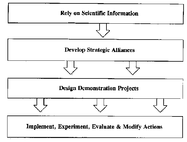
(2) Develop strategic alliances. We are often faced with a broad array of development alternatives the selection and implementation of which require the formation of strategic alliances.
To select the best among a number of development alternatives requires the ability to identify costly and undesirable effects of the possible alternative projects and the opportunity to modify these projects during their design stage. Review and discussion in a variety of forums, including those that are cross-sectoral and those where public participation is encouraged, can greatly strengthen planning because of the alliances that are built up in the process.
By making planning a democratic process through IRDP, people can define their problems and design their own solutions. By the same token, IRDP is strengthened through the formation of networks which make use of a variety of communication techniques to assemble knowledgeable and informed constituencies. Four types of networks are valuable to a communication strategy (Krackhardt, 1993):
a. Advice network. Both planning and implementation require an "advice network" of prominent collaborators on whom others depend (or will depend) to solve problems and provide technical information concerning the strategy, program, or project being developed.b. Trust network. A "trust network" consists of the inner circle of participants who share sensitive political information and back each other in a crisis. These are often the project initiators, who may act as catalysts to help in conflict management or to ensure project implementation through their leadership.
c. Communication network. Participants in the effort should discuss project-related matters regularly. Such a network can be specifically designed to inform politically important individuals on a timely basis, thus ensuring their feedback and support.
d. Constituent network. The need to form an alliance with a number of diverse constituencies often takes the planner into the realm of the unknown. Part of communication is recognizing that we can learn from others. An exchange of ideas is important and at least four approaches can be used to foster this exchange, including information feedback, consultation, joint planning, and delegated authority (Westman, 1985). Information feedback consists of formal and informal one-way presentations, newspaper articles, notices, etc. Consultations are made through such mechanisms as public hearings, ombudspersons, or representatives of the interest groups concerned. Joint planning can take place through the use of advisory committees, structured workshops, etc. And delegated authority is amenable to the use of citizens' review boards and planning commissions.
(3) Design demonstration projects. The value of an interdisciplinary and multifunctional planning team cannot be overstated; alliances forged in the process are indispensable to the success of the decisions that are taken. Innovative demonstration projects must include cross-sectoral representation from the initial stages of their formulation. The design of both the planning process and its products should have clear goals and objectives, review existing legislation and public policy, assess the social and economic conditions of the region, describe important ecosystem structure and function, and analyze direct and indirect threats to both the process and its products (Figure 2).
All of this is more easily done if the region is divided into smaller homogeneous units for analysis and if partnerships are created from the variety of constituencies. A series of strategies, with timetables and benchmarks, should be established with detailed financial goals and budget projections. Visual and graphic tools can be used successfully to communicate the process and products to those who require timely information for decision-making. The successful plan also contains criteria and methods for evaluating progress towards meeting the established goals.
(4) Implement, experiment, evaluate and modify actions. The goal of any planning process is its implementation. Countless development plans that have never been implemented sit on shelves because of problems with funding, politics, myopic vision, or the lack of qualified personnel to take the planning recommendations and make them a reality. In many government settings, the fear of being associated with a project or program that is connected to a current or previous administration can be risky. Developing communication strategies to transfer knowledge to decision-makers can ameliorate this fear.
The implementation of a plan requires that strategies and specific actions be prioritized and that public policy be formulated to do so. Accountability must be maintained, but those who are charged with the implementation of a program must recognize that there are productive failures and that implementation can be modified in positive ways either because of such failures or because of experimentation.
Conclusion
There are no easy solutions to the complex challenges of integrated regional development planning. A process which provides a thoughtful structure for gathering and utilizing scientific information, which involves stakeholders in a genuine analysis of development alternatives, and which establishes clear and measurable objectives can provide for rational development activities, including those for the conservation of biodiversity. Using IRDP as a vehicle to communicate with decision-makers provides a framework for action. Planners often look for what is politically expedient; however, the participation of nongovernmental organizations can play an extremely important role in tempering politically motivated development. This nexus between government and non-governmental organizations is one of the more important areas where "integrated" regional development takes place. Both should represent the interests of both present and future generations.
Thursday, May 17, 2012
saturn


Two of Saturn's 48 known moons are barely visible in this picture of the ringed planet. Mimas, at the upper right, has an enormous impact crater on one side, and Tethys, at the bottom, has a huge rift zone called Ithaca Chasma that runs nearly three-quarters of the way around the moon.


revolution of earth
.jpg)
The Earth is never in the same exact same position from day to day. It moves closer to, and further away from, the Sun. Earth’s perihelion(147,098,074 km) occurs around January 3, and the aphelion around July 4 (152,097,701 km) . The changing Earth-Sun distance results in an increase of about 6.9% in solar energy reaching the Earth at perihelion as related to aphelion. The southern hemisphere is tilted toward the Sun at about the same time that the Earth reaches the closest approach to the Sun, so the southern hemisphere receives slightly more energy from the Sun than does the northern over the course of a year.
The Earth rotates around its axis by moving to the east. The Earth actually rotates 360.9856° in a mean solar day at a speed of 1,674.4 km/h. Earth’s rotation period relative to the Sun (its mean solar day) is 86,400 mean solar seconds. Earth’s rotation period relative to the fixed stars, called its stellar day is 86,164.098 903 691 seconds of mean solar time. Earth’s rotation period relative to the moving mean vernal equinox(its sidereal day) is 86,164.090 530 832 88 seconds of mean solar time, making it slightly longer than the stellar day. Over millions of years, the rotation is significantly slowed by gravitational interactions with the Moon(tidal acceleration/deceleration). Some large scale events, such as the high scoring earthquakes, have caused the rotation to speed up by around 3 microseconds. The speed of the rotation of Earth has had various effects over time, including the Earth’s shape, climate, ocean depth and currents, as well as tectonic forces.
संघीय ढांचे पर आघात
भारत संप्रभु राष्ट्र है, यह अनेक राज्यों के समझौते से मिलकर बना संघ नहीं है। प्रधानमंत्री इस राष्ट्र के महाराज नहीं हैं। राज्य स्वतंत्र देश नहीं हैं। मुख्यमंत्री अपने राज्यों के स्वच्छंद शासक नहीं हैं। संविधान सर्वोपरि सत्ता है। केंद्र और राज्य इसी से शक्ति पाते हैं। राष्ट्रपति, प्रधानमंत्री और मुख्यमंत्री सहित सभी संस्थाएं संविधान से ही अधिकार पाती हैं। संविधान सबको शक्ति देता है, सब पर मर्यादाएं भी अधिरोपित करता है। संविधान ही सर्वोच्च राजधर्म-संहिता है। बावजूद इसके प्रधानमंत्री व तमाम मुख्यमंत्रियों का आचरण सामंत जैसा है। प्रधानमंत्री अपने मंत्रियों के भ्रष्टाचार के भी संरक्षक बन जाते हैं। केंद्र राज्यों के अधिकार पर हमला करने वाले आतंक निरोधी केंद्र जैसे विधेयक लाता है। उत्तर प्रदेश की पूर्व मुख्यमंत्री मायावती ने एक परासंवैधानिक संस्था कैबिनेट सचिव बनाई थी। उनके कार्यकाल में राजकोष से मूर्तियां बनाने सहित एनआरएचएम जैसे हजारों करोड़ के घोटाले हुए। ऐसे आचरण के चलते ही भ्रष्टाचार और कुशासन बढ़ा है, राष्ट्रीयता की भावना भी कमजोर हुई है। राष्ट्रीय अखंडता सर्वोपरि निष्ठा है, लेकिन अधिकांश क्षेत्रीय दल क्षेत्रीयता बढ़ाते हैं और राष्ट्रीयता को कमजोर करते हैं। कांग्रेस राष्ट्रीय दल जैसा आचरण नहीं करती। वह अवसर के मुताबिक क्षेत्रीयता को संरक्षण देती है। शेख अब्दुल्ला ने जम्मू-कश्मीर के लिए अलग निशान, अलग विधान, अलग प्रधान मांगा, कांग्रेस ने दे दिया। लालदेंगा ने राष्ट्रीयता पर हथियारबंद चढ़ाई की, कांग्रेस ने उपकृत किया। तमिल क्षेत्रवाद बढ़ाया था पेरियार ने। उत्तर बनाम दक्षिण का गृहयुद्ध बढ़ाने की कोशिश हुई। केंद्र चुप रहा। आंध्र की एक पार्टी ने स्वयं को तेलगु-देशम बताया। तेलगु देश नहीं भाषा है। तेलगु भाषी भारतीय ही हैं। असम, मणिपुर, नागालैंड सहित समूचे पूर्वोत्तर में क्षेत्रीयता ही राष्ट्रीयता है। मुंबइया राजनीति का क्षेत्रवाद उत्तर भारतीयों पर आक्रामक रहता है। अनेक मुख्यमंत्रीगण क्षेत्रीयता को पोषण देते हैं। वे बहुधा केंद्र पर संघीय ढांचे को तोड़ने का आरोप लगाते हैं, लेकिन संविधान के अनुरूप अपने कर्तव्यों का पालन नहीं करते। संघीय ढांचे का अर्थ मुख्यमंत्रियों की मनमानी नहीं है। इसका सीधा अर्थ है कि केंद्र अपने संवैधानिक दायित्वों का निर्वहन करे और राज्य अपनी जिम्मेदारी निभाए। संविधान का शासन दोनों की जिम्मेदारी है। संप्रग सरकार ने संघीय ढांचे को कमजोर किया है। गैरकांग्रेसी राज्यों की उपेक्षा हुई है। राज्यों के साथ भेदभाव जारी है, लेकिन अनेक मुख्यमंत्रियों ने भी संघीय ढांचे से जुड़े अपने संवैधानिक दायित्वों का निर्वहन नहीं किया। उच्चतम न्यायालय की 9 न्यायमूर्तियों की पीठ ने भी एसआर बोम्मई बनाम भारत संघ मामले में कहा था कि राज्य संघ के संवैधानिक अभिकर्ता के रूप में उसके निर्देशों के अनुसार कार्य नहीं कर रहे हैं। ताजा उदाहरण मायावती का है। वह अपने पूरे कार्यकाल में एक दफा भी किसी केंद्रीय बैठक में नहीं गईं। शिक्षा का अधिकार लागू करने की केंद्रीय अपेक्षा भी कई राज्यों ने नहीं पूरी की। बावजूद इस सबके संविधान के संघीय ढांचे से ही सबको उम्मीद हैं। नए राज्यों की मांगों में राजनीति के साथ संघीय ढांचे के फायदों के आकर्षण हैं। राज्य अनेक शक्तियां मांग रहे हैं। जम्मू-कश्मीर की राजनीति स्वायत्ततावादी है, लेकिन 1983 में तमिलनाडु से उछली अधिक स्वायत्तता की मांग में तमाम गैरकांग्रेसी राज्य भी जुड़ गए थे। सरकारिया आयोग की सिफारिशें (1988) भी संघीय ढांचे के पक्ष में थीं और राज्यों का हित मजबूत करने वाली थीं। लेकिन संघीय ढांचे की मजबूती का सारा दारोमदार प्रधानमंत्री और मुख्यमंत्रियों के कर्तव्य निर्वहन पर ही टिका हुआ है। संविधान में राष्ट्र-राज्य के नीति निर्देशक तत्वों की खूबसूरत सूची (अनुच्देद 36 से 51) है। अनुच्छेद 37 में कहा गया है कि संविधान का यह हिस्सा न्यायालयों द्वारा लागू नहीं किया जा सकता, फिर भी इसके तत्व शासन के मूलाधार हैं। इन्हें कानून बनाने में लागू करना राज्य का कर्तव्य होगा। संविधान निर्माताओं ने हमारे शासकों को तमाम कर्तव्य भी दिए हैं। संविधान के अनुसार सामाजिक, आर्थिक और राजनीतिक न्याय के तत्व सभी संस्थाओं में होने चाहिए। यहां समान नागरिक संहिता भी राज्य का कर्तव्य है। गोवंश संरक्षण और उनका वध रोकना भी नीतिनिर्देशक तत्व हैं। समान नागरिक संहिता पर केंद्र ने अपना फर्ज नहीं निभाया। गुजरात, मध्य प्रदेश, उत्तर प्रदेश आदि के मुख्यमंत्रियों ने गोवंश वध निषेध पर पहल की थी, लेकिन देश के अधिकांश हिस्सों के मुख्यमंत्रियों ने इस निदेशक तत्व की अवहेलना की। राज्य क्षेत्र में भ्रष्टाचार रोकने की जिम्मेदारी मुख्यमंत्रियों की ही है, लेकिन ढेर सारे पूर्व मुख्यमंत्रियों पर भ्रष्टाचार के आरोप हैं। लोक व्यवस्था व पुलिस राज्यों का विषय है। लेकिन पुलिसतंत्र मुख्यमंत्री की पार्टी की निजी पलटन बन जाता है। पीडि़तों को सुरक्षा नहीं मिलती। संविधान ने राज्यों को तमाम अधिकार दिए हैं। मुख्यमंत्री ही राज्य का प्रमुख शासक है। वह सरकार का वास्तविक प्रधान है। लोकव्यवस्था, कृषि, जनस्वास्थ, भूमि और भूमि सुधार, सिंचाई, खनिज विकास, राज्य लोकसेवाएं, भू-राजस्व आदि अनेक विषय राज्य सूची में हैं, लेकिन क्षेत्रीय दल चलाने वाले मुख्यमंत्री राजनीति को सर्वोपरि महत्व देते हैं। तब पार्टी और सरकार एक हो जाते हैं। प्रशासनिक संवेदनशीलता का नामोनिशान नहीं होता। कुछ मुख्यमंत्रियों के अपने प्रिय औद्योगिक घराने और पालतू माफिया होते हैं। भ्रष्टाचार का संस्थागत हो जाना इसी संकीर्ण राजनीति का परिणाम है। वे अपनी क्षेत्रीय ताकत के अनुसार केंद्र को चुनौती देते हैं। केंद्र मोलभाव करता दिखाई पड़ रहा है। वे धमकाते हैं, केंद्र डर जाता है। केंद्र सीबीआइ जांच का डर दिखाता है, वे सौदा कर लेते हैं। भ्रष्टाचार बढ़ रहा है। न्यायालयों के हस्तक्षेप से ही कार्रवाई होती है। तमाम मुख्यमंत्री अपना कर्तव्य नहीं निभाते, केंद्र गठबंधन राजनीति को कोसता है और गठबंधन से ही सत्ता चलाता है। राष्ट्र स्थायी सत्य है और राष्ट्रीयता स्थायी राष्ट्रधर्म। मुख्यमंत्री इसी राष्ट्र की माननीय संवैधानिक संस्था हैं। मुख्यमंत्रियों को राष्ट्रभाव संवर्द्धन का काम करना चाहिए। शोषण और भ्रष्टाचार मुक्त शासन उन्हीं की जिम्मेदारी है। उत्तर प्रदेश सहित कई राज्यों में भ्रष्टाचार की बाढ़ है। कानून व्यवस्था की स्थिति खराब है। राजकोष लुट रहा है। वे क्षेत्रीय, जातीय सवाल उठाकर ताकत बढ़ाते हैं। आम आदमी पीडि़त है। आखिरकार विभिन्न राज्यों में बढ़ रहे भ्रष्टाचार का मुख्य दोषी कौन है? लोकसेवाओं में व्याप्त भ्रष्टाचार को दूर करने की जिम्मेदारी है किसकी? मुख्यमंत्री अपनी जिम्मेदारी से बच नहीं सकते।
...............BY Hriday Narayan Dixit..............published in dainik jagran
Wednesday, May 16, 2012

| ||
National Water Development Agency (NWDA) was set up in July, 1982 as Autonomous Society under the Societies Registration Act, 1860, to carry out the water balance and other studies on a scientific and realistic basis for optimum utilisation of Water Resources of the Peninsular rivers system for preparation of feasibility reports and thus to give concrete shape to Peninsular Rivers Development Component of National Perspective. In 1990, NWDA was also entrusted with the task of Himalayan Rivers Development Component of National Perspectives. Recently, the functions of NWDA have been further modified and the work of preparation of detailed Project Reports (DPR) of various link proposals and Pre-feasibility Reports and feasibility reports of intra-State links as proposed by the States have been included in the functions of NWDA.
FUNCTIONS OF NWDA:
a) To carry out detailed surveys and investigations of possible reservoir sites and interconnecting links in order to establish feasibility of the proposal of Peninsular Rivers Development and Himalayan Rivers Development components forming part of National Perspective for Water Resources Development prepared by the then Ministry of Irrigation (now Ministry of Water Resources) and Central Water Commission.
b) To carry out detailed surveys about the quantum of water in various Peninsular River Systems and Himalayan River Systems which can be transferred to other basins/States after meeting the reasonable needs of basin/states in the foreseeable future.
c) To prepare feasibility report of the various components of the scheme relating to Peninsular Rivers development and Himalayan Rivers development.
d) To prepare detailed project report of river link proposals under National Perspective Plan for Water Resources Development after concurrence of the concerned States.
e) To prepare pre-feasibility/feasibility report of the intra-state links as may be proposed by the States.
f) To do all such other things the Society may consider necessary, incidental, supplementary or conducive to the attainment of above objectives.
|
world ITFORUM-5
WITFOR - 5
India hosted the World Information Technology Forum (WITFOR) 2012 on April 17 and 18, 2012 in Vigyan Bhawan, New Delhi. This was the fifth edition of the event. It was organised by the International Federation for Information Processing (IFIP), in partnership with the Department of Electronics & Information Technology (DEITy), Ministry of Communications & Information Technology, Government of India.
Representatives from over 30 countries shared their knowledge, views and best practices in the use of IT for governance and delivery of key public services.
The next event, WITFOR 2013 will be held in Paraguay.
Focus areas of WITFOR - 5
WITFOR – 5 deliberations mainly focused on the use of ICT in agriculture, education, health and e-Governance, within the overall theme of ‘ICT for Sustainable Human Development’.

The Forum also discussed the role of IT interventions in bringing about greater transparency in governance, issues of privacy and security while dealing with public databases, financial inclusion and ways of leveraging wireless technologies.
Background
WITFOR was born out of the need for emerging economies and developed countries to collaborate and harness the potential for digital technologies for sustainable development. Since its inception in 2003, World IT Forums have been held four times–in Vietnam (2009), Ethiopia (2007), Botswana (2005) and Lithuania (2003).
The activities of the Forum are broadly guided by the World Summit on the Information Society’s (WSIS) Plan of Action, in order to help achieve the UN Millennium Development Goals (MDGs).
Significance of such events for India
As a country with enormous ICT capabilities and equally immense socio-economic development challenges, India attracts significant international attention for its efforts to exploit the developmental potential of ICT. At the same time, Indian policymakers and practitioners can learn from the experiences of other countries. WITFOR 2012 provided a unique opportunity for sharing knowledge on mobilising ICT for development, among a diverse range of professionals engaging in this effort in many countries with a variety of development challenges.
Thus, WITFOR 2012 provided a valuable forum for understanding how the power of ICT can be harnessed for sustainable development.
comparison between missiles of India,China, and Pakistan

Missile power of China and Pakistan
- Both China and Pakistan possess formidable nuclear-armed missiles of their own.
- From bases in Qinghai and Yunnan provinces, these missiles can reach all of India.
- China is in the process of replacing its liquid-fuelled ballistic missiles with more modern solid propellant ones.
- Further, in 2004, China launched the first of its second-generation Type 094 Jin-class nuclear-powered submarines that will carry JL-2 solid-propellant ballistic missiles.
- Pakistan too has a number of long-range missiles in its armoury. An assessment carried out by an Indian strategic studies group found that Pakistan had a credible deterrent structure organised around the solid-propelled Shaheen-1 and -2 missiles

The Agni family of missiles
- The family of Agni surface-to-surface ballistic missiles forms the mainstay of India's strategic defence capability to meet various threats.
- All Agni missiles are propelled by solid fuel and can carry nuclear warheads.
- As these missiles use solid propellants and can therefore be launched at short notice.
- They are also carried on mobile launchers, making it more difficult for an enemy to locate and destroy them.
- The first in the series was Agni-II with a range of 2,500 km, followed by Agni-I (700 km), Agni-III (3,000 km), Agni-IV (3,500 km) and Agni-V (5,000 km) now.
- Agni-I, Agni-II and Agni-III have been inducted into the Army.
- Agni-I (700 km) is a single-stage missile, which is 15-metre tall and weighs 12 tonnes. It is Pakistan-specific, and was built in a record 18 months after the Kargil conflict.
- Agni-II with a range of 2,500 km is a two-stage missile, 20-metre-long and weighs 17 tonnes.
- Agni-III (3,000 km) is also a two-stage missile, which is 17 metres long and weighs 50 tonnes.
- The first development trial of Agni-IV, which has a strike range of more than 3,500 km, took place on November 15, 2011. It is not yet inducted into the Army.
Strategic significance
- With India's policy of no-first-use of nuclear weapons, Agni-V will provide the country with depth in deterrence.
- Agni-V, with its long range, will bring the whole of China as well as other regions under its strike envelope. Even though India cannot match China in terms of its vast nuclear and missile arsenals, missiles like Agni-V and the 3,500-km Agni-IV, tested in November 2011, will certainly add strength to its credible minimum nuclear deterrence posture.
- With a canister-launch system to impart higher road mobility, the missile will give the armed forces much greater operational flexibility than the earlier-generation of Agni missiles.
- The accuracy levels of Agni-V and Agni-IV, with their better guidance and navigation systems, are far higher than Agni-I (700-km), Agni-II (2,000-km) and Agni-III (3,000-km). This feature enables precision strikes with minimal collateral damage.
- The Agni missiles will get even more effective once MIRV (Multiple Independently Targetable Re-Entry Vehicles) payloads for them are developed. An MIRV payload on a missile carries several nuclear warheads, which can be programmed to hit different targets. A flurry of such missiles can hence completely overwhelm BMD (Ballistic Missile Defence) systems.
- Agni-V can perform different roles, from carrying multiple warheads to providing anti-satellite capability and even launching tiny satellites into orbit.
- Agni V, India's most powerful long-range ballistic missile, also established the superb R&D capabilities of the Defence Research & Development Organisation.
Subscribe to:
Posts (Atom)